Since the mid-2000s, I have walked across nearly all of Southwest England, and much of the rest of the country, by public transport. Some of my walks have used buses; most have used rail. That gave me the idea to set up www.railwalks.co.uk which is aiming to create a national network of walks between railway stations.
Many of the places I walk are in remote countryside with no public transport. If that sounds puzzling to you, then please read on.
I live in a city centre, near the main railway station and many bus routes. Obviously, the range of possibilities is greatest if you live near a transport hub, and some cities are surrounded by more walkable countryside than others, but anyone living near a railway station and a bus stop will have some possibilities.
If you want to walk everywhere by public transport the first rule is: don’t start by thinking about destinations. Instead, I follow three simple steps:
- Look for places with frequent public transport where it is possible to finish.
- Look for places with any public transport where it is possible to start.
- Look at all the potential walking routes between those places.
You will find the most interesting places to walk, through beautiful, remote and surprising countryside, in between.
The starting points might have only one bus a day. As long as it’s at a convenient starting time, that’s enough. The starting points might be ugly or boring; that doesn’t matter, because as soon as you get there you will be walking away from them. Walking from point to point, instead of circling around a car park, takes you further from your starting point, through a wider range of scenery than it’s possible to walk through by car, which is one reason I enjoy it so much.
So how can you walk through countryside where there’s little or no public transport? Here is one example, from the Cotswolds. The area shown below is bounded by two railway lines. To the north and east of those lines, there are a few buses on the main roads, and miles of countryside where you will rarely see a person, let alone a bus.
The map shows nine walking routes between seven places. Six of those are towns with railway stations. The seventh, Winstone, has an infrequent bus service starting from Gloucester railway station. You can start there in the morning and walk to Kemble, Stroud or Cheltenham railway stations to finish.
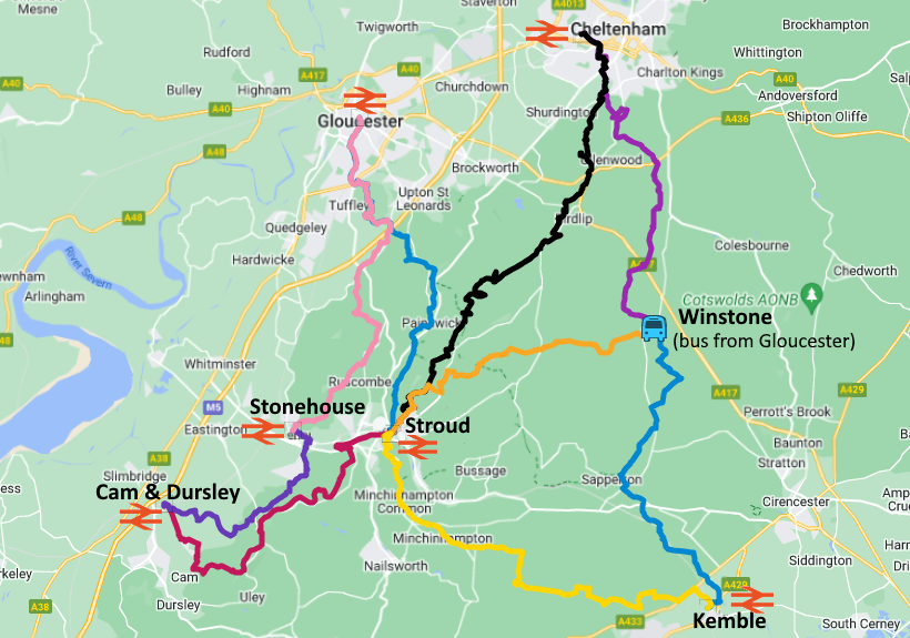
That bus stops at several other places, where you could equally choose to start your walk. Between each of the places shown on the map there are many possible routes, so within that small area, there are dozens of possible walks. Further north and east, there is more quiet countryside, more infrequent buses, and another railway line on the opposite side of the Cotswolds. Most of rural England is like that.
Planning journeys by public transport is much easier nowadays. For rail journeys, you can use any of the rail operators’ apps. If your journey involves a combination of rail and bus, Google Maps is probably the easiest place to start. The apps of the main bus operators give more detailed information: some of them even show the location of each bus moving along the route
To plan the walk, you either need to read a map and work it out for yourself, or else look for walks done by other people. This website includes many distributed across the country.
If you live in or near Bristol, I have created a spreadsheet listing 100 different combinations of starting and finishing points, using trains and/or buses. I am gradually adding gpx files, which you can download into a mapping app, such as Outdoor Active, OS Maps or Komoot. The video explains how to import a gpx file if you haven’t done that before.
You might be thinking: what about more remote places, where the gaps between public transport are more than a day’s walk? Then you need to stay overnight, which would take another article to describe. In England, there are very few areas like that (although I sometimes stay overnight to walk in places further away from my home). There are obviously more in Scotland and Wales. With a few exceptions, walking the English or Welsh Coast Paths means staying overnight. I have walked all of the Southwest and Pembrokeshire Coast Paths, and the Llyn Peninsula for an article in Coast Magazine, by public transport, walking a few days at a time.
I didn’t set out to write about all this. It’s what I’ve always done in my leisure time, since I moved to the city and gave up driving. Then I started to notice that other people had no idea this was possible. They seemed to think that you can only walk in a few places by public transport, and you need a car to access remote rural areas. As the centres of our cities densify, with more flats and no more parking space, there are more people living there without cars. I want to help them (and some others) to realise that you don’t need a car to enjoy the countryside.